Lakes of Kyrgyzstan

Duration: 16 days, 15 nights
Season: June – October
Route: Chui, Issyk-Kul, Naryn, Djalal-Abad, Osh region
Conditions: there is not a lot of physical exertion throughout the journey. But there will be several long transfers about 7 hours a day and travelers will reach an altitude up to 3500 m.
Kyrgyzstan as well known is a mountainous country with many snowy peaks and beautiful valleys, glaciers and rivers, and of course mountain lakes which are worth singling out. On the territory of Kyrgyzstan there are about 2000 lakes of different origin: tectonic, clod, glacial and karstic. There are lakes that rightfully compete in size with the seas, and also there are small pearls which are hidden from the eyes and so small that you will never find them on the map, but they are really beautiful and magnetic.
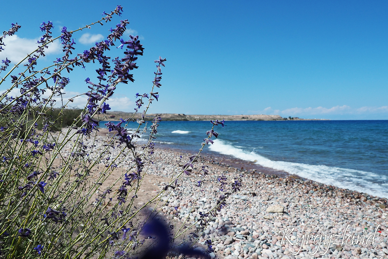
The three largest lakes of Kyrgyzstan - Issyk-Kul, Son-Kul, Chatyr Kul and Sary-Chelek, are the most attractive and accessible for tourists. During the tour - Lakes of Kyrgyzstan travelers will have the opportunity to visit all three lakes and also the beautiful and hard-to-reach lake Kel-Suu.
First of all, drive from Bishkek towards Lake Issyk Kul. Next, drive up the Arabel plateau. There is a large number of mountain lakes with crystal clear water. The next destination will be Son Kul Lake. Located at an altitude of 3016 meters above sea level. Its surface is 278square km. The part of the lake belongs to the Karatal Zhapyryk reserve. Move towards the Chinese border. We will visit a historical attraction - the caravanserai "Tash Rabat". A place where travelers, caravans stopped moving along the Silk Road. We will visit Chatyr Kul Lake (3530m). Further, visiting Kel Suu Lake, which is located in the inaccessible region of the Naryn region of the Kakshaal Too ridge. It’s also near Chinese border. The Lake is situated in between the high cliffs. The water in the lake changes from green to turquoise, and sometimes disappears. The name of the lake if to translate from Kyrgyz sounds like "coming water." Then move to the south of the country. Driving to Sary Chelek Lake and as well, the largest reservoir in Central Asia - Toktogul. Return back to Bishkek through the Chichkan gorge, the alpine Suusamyr valley, Ara Bel and Too Ashuu passes. Down the serpentine road to the Chuy valley.
Day 1.
Airport “Manas”– Bishkek city – Tamga village (370 km)
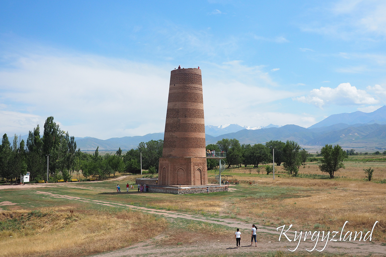
Arrival in airport “Manas”(early morning arrival). Transfer to Bishkek with a great view to Kyrgyz Ala Too Mountain Range. Drive to the Tamga village via Burana Tower, which is UNESCO heritage (11-12 century A.D.). During the excursion, we climb up 24 meters Tower and see the beautiful Chui valley and Kyrgyz Mountain Range from above. Then continue driving towards Tamga village. Pass through Boom Gorge, which separates Chui and Issyk Kul valleys. “Boom” means “narrow”. It is a scenic place with stormy Chui river, winding road, mottled rocks and clear mountain air.
Dinner in Tamga Village. Overnight in a guesthouse.
Altitudes (above sea level): Bishkek – 700-800m; Tamga – 1685m
Day 2.
Tamga village – Barskoon gorge – Arabel pass – Tamga village (80 km one direction)
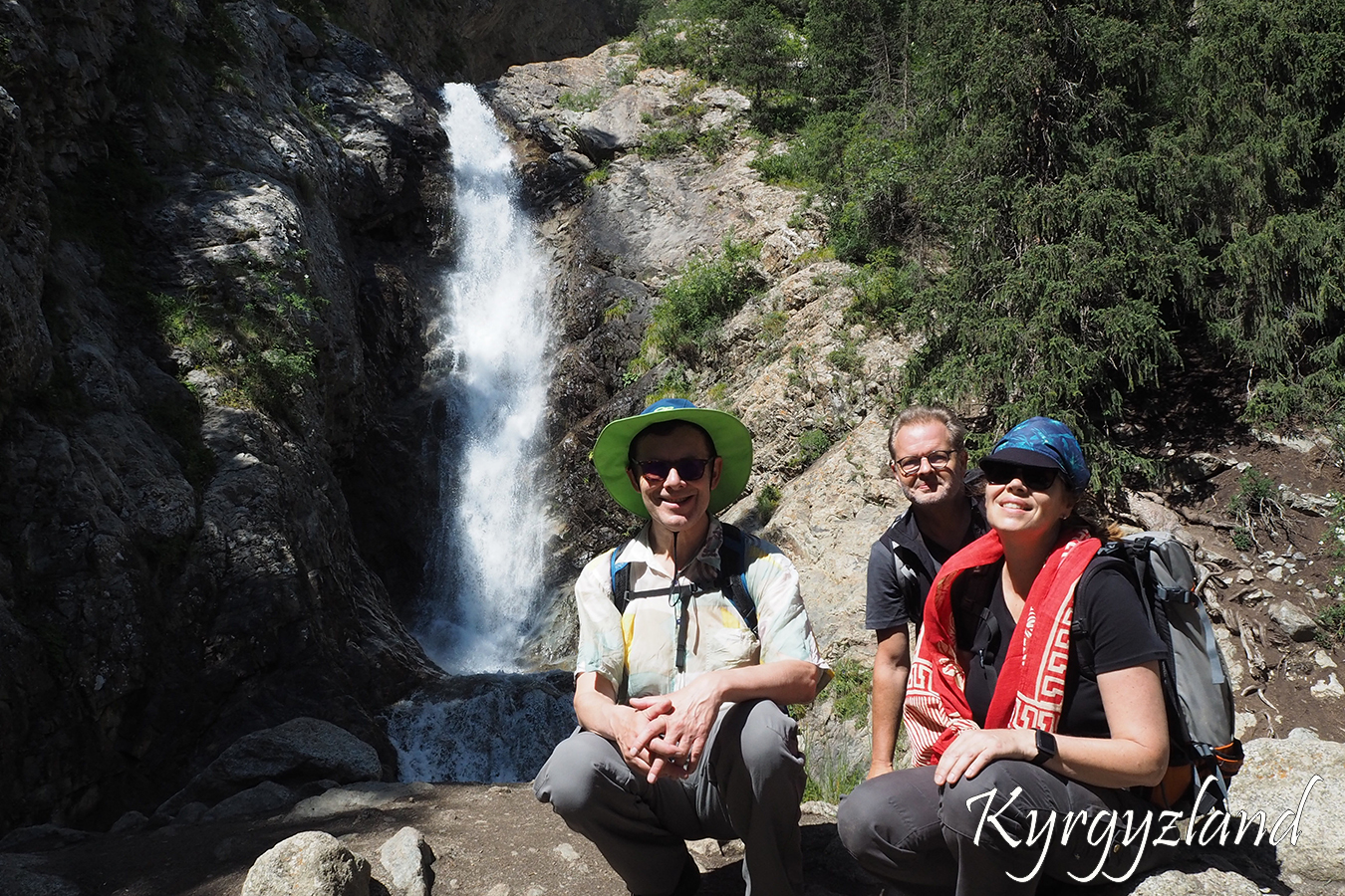
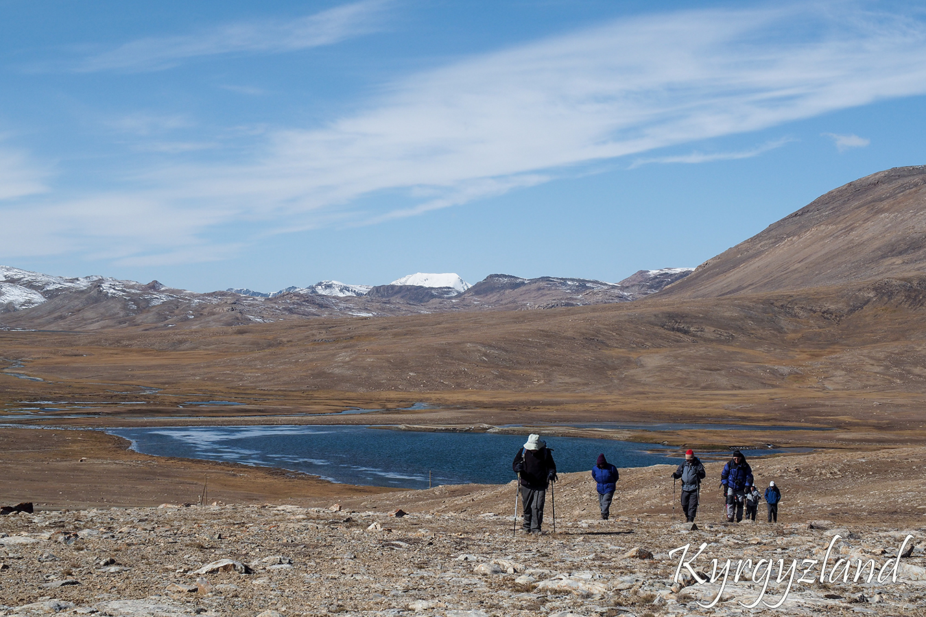
Drive to Barskoon Gorge to visit Waterfalls after breakfast in the guest house. Our first stop at the memorial of the first cosmonaut Yuriy Gagarin, who had visited this Gorge long time ago. From here you may see big and strong waterfall, which calls “Snowleopard’s jump”, considered as one of the most beautiful in Kyrgyzstan. There are also two more waterfalls – “Snowleopard’s tears” and “The cup of the Manas”. Next step is drive up to Barskoon pass along beautiful mountain road which follows “Kumtor” Gold mining and further to Inner Tien-Shan. Goal of this trip is excursion to Arabel valley. It is high-mountain plateau consist of permafrost, surrounded by ice-covered mountain ridges. All valley is plenty of lakes with crystal clear water. Drive back to Tamga after small walk.
Dinner and overnight in a guesthouse.
Altitudes (above sea level): Tamga –1685m, Arabel pass – 3800m
Day 3.
Tamga village – Son Kul Lake (300 km)
Drive to Son Kul Lake passing by Orto Tokoi reservoir after early breakfast. Stop for lunch in Kochkor village. Visiting craft shop-museum on the way for buying souvenirs. Continue driving to Son Kul Lake over Kalmak Ashuu pass. Son Kul is high altitude lake situated on a flat and open valley, surrounded by endless green pastures and smooth hills. It is unforgettable landscape symbolizing Kyrgyz Nomad’s life. There we stop in a Yurt camp, where can get acquainted with traditions of nomadic life.
Dinner and overnight in a Yurt camp.
Altitudes (above sea level): Tamga – 1685m, Son Kul – 3016m, Kalmak Ashuu pass – 3446m
Day 4.
Son Kul Lake – Naryn town (150 km)
Begin this day with excursions around the area. Visit historical monument “Manas’s fireplace”. Horse riding trip along the lakeside or hiking trip to see petroglyphs placed on mountain hill with beautiful panorama of the Lake. Continue travel to Naryn town over Moldo Ashuu pass after lunch.
Dinner and overnight in a guesthouse or hotel.
Altitudes (above sea level): Son Kul – 3016m, Naryn – 2000m, Moldo Ashuu pass – 3174m
Day 5.
Naryn town – Kel Suu Lake (180 km)
Transfer to Kel Suu Lake. Road follows to At Bashy valley first, then further through beautiful Bosogo canyon to wild and rough Ak Sai valley. You would feel real adventure when passing Ak-Sai, which means a White Valley in Kyrgyz language. Breathtaking views to Kokshaal Too Range, rapid mountain rivers and fresh mountain air awaits you there.
Have a short walking tour upon arrival to destination point.
Dinner and overnight in a Yurt Camp.
Altitudes (above sea level): Naryn – 2000m, Yurt Camp – 3350m
Day 6.
Kel Suu Lake
Hike or horse ride to the shore of Kel Suu Lake.
Kel Suu is a high mountain lake located close the Chinese border. From the both sides there are huge vertical rocks. The lake is around 9 km long, maximum depth 10 m. It is located on the height of 3500m above sea level. The water is cold and fresh. The color of the lake changes with the weather from turquoise to deep blue. During trip to the Lake we may visit a cave and climb a bit up to see the panorama view of the lake. Then return back.
Dinner and overnight in a Yurt Camp.
Altitudes (above sea level): Kel Suu –3500m
Day 7.
Kel Suu Lake – Tash Rabat Caravanserai (280 km)
Breakfast in the yurt camp, then start driving to Tash Rabat Caravanserai. Tash Rabat is located in the Western part of At-Bashi Range, in a mountain valley called by name of this famous building. It was built in the XV century on the site of an older monastery of the X-XI cc. It’s one of the most important representative of historical architecture, appeared in period of activation of the Great Silk Road on Tien–Shan, saved to our days.
Excursion to Caravanserai and nearby. You may have a little hike up to the hills to see beautiful panorama of the place.
Dinner and overnight in the Yurt camp.
Altitudes (above sea level): Kel Suu – 3500m, Tash Rabat – 3500m
Day 8.
Tash Rabat Caravanserai – Chatyr Kel Lake– Tash Rabat Caravanserai (90 km one direction)
There are two options to reach the Lake: by car along the road towards Torugart pass or trekking to Tash-Rabat pass (by foot or by horse).
Chatyr Kul is the third largest lake in Kyrgyzstan. It’s located near the Torugart Pass border crossing into China. The name of the lake means “Celestial Lake” in Kyrgyz. It occupies an area of 175 sq. km. The lake is a part of Karatal-Zhapyryk National Wildlife Refuge. The shore of Chatyr-Kul is a habitat of various species of animals and birds: snow leopards, marmots, mountain goats and mountain geese.
Dinner and overnight in a yurt camp.
Altitudes (above sea level): Tash Rabat 3500m, Chatyr Kul 3530m, Tash Rabat pass 3965m
Day 9.
Tash Rabat caravanserai – Kazarman village (180 km)
Drive to Kazarman village. Road lies along Naryn river valley. The highest point today would be Kara-Koo pass 2800m. There would be amazing view to the valley and strong Naryn river.
In Kazarman we stop in a guesthouse. Dinner is also there.
Altitudes (above sea level): Tash Rabat – 3500m, Kazarman – 1310m
Day 10.
Kazarman village – Arslanbob valley (230 km)
Start driving to the Arslanbob valley. Get over beautiful high mountain meadows, following Sary Kyr mountain ridge and drive down Fergana valley. As well at one point there could be seen rice fields. Stop for lunch in Jalal Abad city. Then drive directly to Arslanbob.
Dinner and overnight in guesthouse.
Altitudes (above sea level): Kazarman – 1310m, Arslanbob – 1600m
Day 11.
Arslanbob valley
The Arslanbob is the largest walnut area on the planet. It covers over 600,000 hectares. Up to 1,500 tons of walnuts are harvested every year in the Arslanbob Valley, also 5,000 tons of apples, pistachios, and cherry plums. Arslanbob area is now a forest zone protected by the state.
We would have trek through to walnut forest to the little waterfall, which is about 25 m. After that, we will walk to a panorama place from where you will be able to see the whole valley. After go down to the village for lunch. Then we drive to the village outskirts to visit big waterfall.
Dinner and overnight in a guesthouse.
Altitudes (above sea level): Arslanbob – 1600m
Day 12.
Arslanbob valley – Arkit village (230 km)
After breakfast, start driving towards Arkit village. On the way there will be several abandoned industrial towns from Soviet Union times. We’ll pass tunnels and could see Tash-Kumyr Hydro Power Plant.
Dinner and overnight in a guesthouse.
Altitudes (above sea level): Arslanbob – 1600m, Arkit – 1302m
Day 13.
Arkit – Sary Chelek – Arkit (25 km one direction)
Breakfast, then drive to the Lake Sary Chelek which means “yellow basket”. It’s the second deepest Lake in Kyrgyzstan. Average depth is 98m, maximum 234m. Length of the Lake is 7,5 km. To reach the North side of the Lake is possible by boat or hiking horse path, which goes from the West shore side. Sary-Chelek Lake is located in the foothills of the Chatkal ridge, in the state reserve, which since 1979 is a member of the international network of biosphere reserves of UNESCO. The territory of Sary-Chelek reserve covers 23.8 thousand hectares. In addition to Sary-Chelek, there are seven more mountain lakes on it. For Kyrgyz people this Lake is sacred. Also from the South side there some holy places are situated: two mosques and spring with healing water. Long ago there lived hermit Buddhist community. After excursion drive back to Arkit.
Dinner and overnight in a guesthouse.
Altitudes (above sea level): Sary Chelek – 1940m
Day 14.
Arkit – Chychkan gorge (250 km)
Start driving towards Chychkan valley after breakfast. Stop for lunch at Toktogul reservoir. There locals prepare delicious fish.
“Chychkan” means “a mouse”. There runs Chychkan river, which flows into Toktogul reservoir. If feel like walking, trekking to Itagar gorge, where is situated Saz-Kel lake.
Chychkan gorge’s slopes covered with mixed forest.
Dinner in a café, accommodation in a guest house.
Altitudes (above sea level): Chychkan gorge – 2200m
Day 15.
Chychkan valley – Bishkek (270km)
Start moving towards Bishkek right after breakfast. Get over first Alabel pass. Traversing mountain Suusamyr valley. Get over next Too Ashuu pass. After tunnel there is beautiful serpentine road down to the valley. Sightseeing excursion in Bishkek. Visiting oriental market “Osh bazaar”, main square Ala Too, oak park.
Farewell dinner in a traditional cuisine café.
Overnight in a hotel.
Altitudes (above sea level): Chychkan gorge – 2200m, Alabel pass – 3184m, Too Ashuu pass –3180m, Bishkek – 700-800m
Day 16.
Bishkek – Airport (35 km)
Early breakfast. Driving to the airport. Flight home.
Altitudes (above sea level): Bishkek – 700-800m, “Manas” airport – 650m
Service includes:
Double or twin accommodation in guesthouses/ hotels according program
Transport for transfers during tour
Full board during tour
English speaking guide
Servise doesn't include:
Accommodation in hotels before and after the program
Alcohol and soft drinks
Transfers, excursions or horse riding over the program etc.
Visa and invitation letter to Kyrgyzstan
Medical insurance
Clothing and Equipment:
Sunscreen (at least 20SPF)
Chapstik or equivalent lip balm
Sunglasses with UV protection
At least a 25 Liter backpack for personal items
Sleeping bag
Sleeping mat
Telescopic trekking sticks poles (optional)
Head lamp (eg Petzl) spare bulbs & batteries
T-Shirts, long-sleeved T-shirt, shorts
Trekking pants
Underwear
Fleece jacket or pullover
Fleece Wind-Stopper jacket (optional)
Down vest and/or jacket (optional)
Waterproof jacket (Gore-Tex) with hood
Waterproof pants (Gore-Tex)
Thick, warm wool hiking socks
Thin gloves for trekking and overnight
Sun hat or scarf
Warm fleece hat or light balaclava
Trekking/Hiking boots with spare laces
Footwear for around camp, eg running shoes and/or sandals